About the GIS-Technologies Department
GIS-Technologies a division of the Chief County Assessment Officer and provides on-going development, maintenance and support of the enterprise GIS systems along with the maintenance of a number of GIS data layers.
The enterprise GIS systems used by county offices include applications developed for the desktop and the Intranet/Internet platforms.
GIS-Technologies also provide assistance to other county departments such as GIS planning, managing, analysis, custom application development, geo-coding services, training and user group meetings.
GIS-Technologies a division of the Chief County Assessment Officer at Franklin County is responsible for:
- Coordinating, implementing, developing and maintaining Franklin County’s Geographical Information System (GIS) including creating and managing GIS files and related procedures, and educating GIS Users
- Coordinating with the Chief County Assessment Officer, maintaining datasets and databases and researching and resolving problems
- Responsible for all mapping changes due to real estate transfers.
- Maintain the GIS base map with property splits and combinations and maintain the genealogy for each parcel with the Parcel Builder program.
- Answer taxpayer’s questions regarding their property descriptions.
- Act as the County Plat Manager with full knowledge of the Illinois Plat Act
GIS Schedule of Fees
Assessment Copies
DevNet Parcel Report = $0.50 per page (1-49 copies)
Property Record Card = $0.50 per page (1-49 copies)
50 – 99 Copies = $0.25
100 or more copies = $0.10
GIS Map Copies
Black and White with Aerial Photo = $2.00 per page (8½” x 11”)
Black and White without Aerial Photo = $1.00 per page (8½” x 11”)
Color with or without Aerial Photo = $5.00 per page (8½” x 11”)
Color with or without Aerial Photo = $25.00 per page (24” x 36”)
GIS Digital Mapping Data
Arc Map Shapefile = $.10 per parcel (without attached data)
Arc Map Shapefile = $.20 per parcel (with attached data)
Excel Spreadsheet = $.10 per parcel
Note:
Requires map of parcel area or Parcel ID Number list
Requires three business days notice
Franklin County GIS Website
The User Fee for the G.I.S. Website is a convenience fee for the use of the website outside the Franklin County Offices and during non-business days and times.
*Individual Yearly Fee = $200.00
*Individual Monthly Fee = $20.00
*Individual Weekly Fee = $10.00
**Business Yearly Fee = $400.00
**Business Monthly Fee = $40.00
**Business Weekly Fee = $10.00
The Week Fee will be due at the first of the calendar week and will be usable for that calendar week.
The Monthly Fee will be due at the first of the calendar month and will be usable for that calendar month.
The Yearly Fee will be due at the first of the calendar month and will be usable for a full 12 months.
*Each User Name and Password for Individual is for the personal use of the website at any computer.
**Each User Name and Password for Business is for the use of the website for the employees in a physical office and can be used during non-business days and times, each satellite office will need its own User Name and Password.
Franklin County assumes no liability whatsoever associated with the use of misuse of this map resource and disclaims any representation or warranty as to the accuracy of the data. This map is compiled from official records and only contains information required for local government purposes.
Please contact the GIS Department to report any data inaccuracies.
The GIS maps and information are not to be sold or redistributed without the permission of the Franklin County GIS Department.
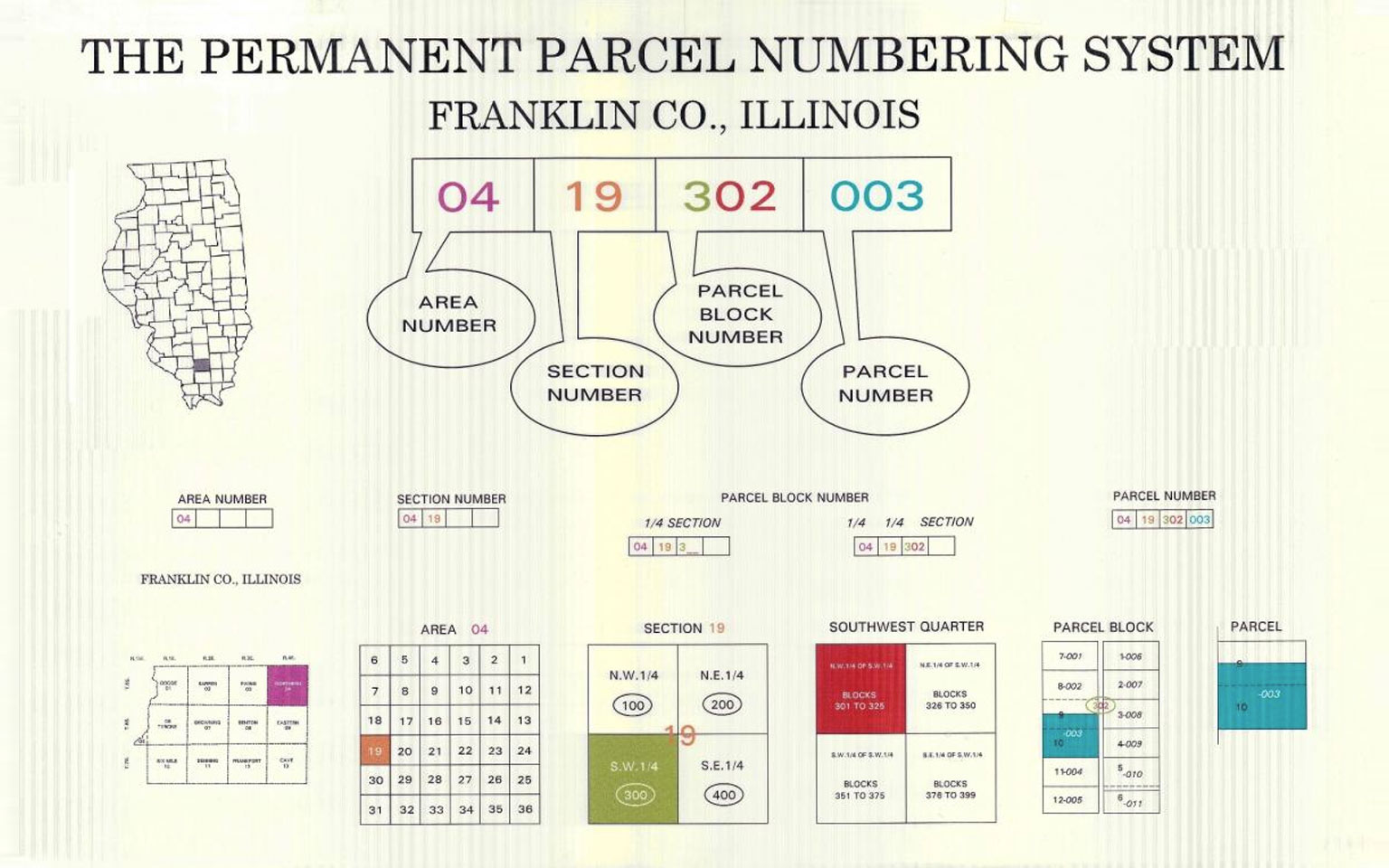
How to Read Parcel Numbers
Use this graphic illustration to learn how to read parcel numbers.
GIS Development
Franklin County GIS Website (Portico) for users: CLICK HERE
The Portico is being provided by the Franklin County GIS and Chief County Assessment Officer through the Sidwell Company.
Basic tips for use of the Portico are as follows:
The top left is the zoom and pan icon. It is used to zoom in and out for scale and pan in all directions. Zooming in or out, you will see that the map changes what is being shown as compared to the scale you are using.
The first icon on the middle left is search. Type the index number with no dashes, owner’s name with last name first, or the address in the oval to the right of the icon. The address is only available if the parcel has an address in the Supervisor of Assessments Office. If the parcel does not have a living area, it will not have a site address.
The second icon is select features. Using this icon, you can left click a dot or hold down and draw a line to select parcel(s), then in the results area the parcel(s) information is shown. If many parcels are selected, click on one of the parcels in the results area to get the individual parcel. Information shown is owner’s name(s), site address (unverified), index number, last recorded document (if available), property class, tax code, assessment information and tax billed prior year. More information on exemptions and tax legal descriptions are coming as soon as we have it available.
The third icon is select features and buffer. It is the same as select features but you can give a distance buffer from the point or line drawn to be included in the selection.
The fourth icon is identify. It gives you the same results window as select features and a down arrow window that shows all map layers associated with the picked parcel.
The fifth icon is measure. You can use this to draw lines on the map by left click the mouse on the map and a line with a distance is shown until you left click again. When you have drawn a polygon area and left click on the first point, the polygon will fill in and show the area of the polygon in either square feet or acres, changeable by using the down arrow field.
The fifth icon is zoom to coordinate. This can be used if you have a coordinate of latitude and longitude, Illinois State Plane East, or UTM Zone 16N.
The sixth is bookmark. Use this icon if you want to mark a spot on the map that you will be revisiting often.
The seventh icon is layers. Using this icon you can fade or remove a layer by using the slidebar next to the layers of Aerials, Cadastral, Land Use or Floodplain. This window also has the map tips and legend toggles on it.
The eighth icon is print. Using this icon will start a popup screen of the map with north arrow, scale bar and legend. Be sure to use landscape on your printer setup and use the print now at the bottom of the screen.
The ninth icon is to toggle the tool tips on and off.
The Portico map is updated by changes made from the G.I.S. on first of every month. The assessment information is updated on a nightly basis. The current aerial photo is from 2005 and 2012 will be added in the fall of this year.
“While the Franklin County Chief County Assessment Office has made every effort to insure a good level of accuracy for the GIS data, we advise they are to be used as an informational tool only; and are not meant to be used for projects requiring survey accuracy. As such the Franklin County Chief County Assessment Office makes no explicit warrant to users. Franklin County assumes no responsibility for any loss or delay that might result from its use.”
Please contact the GIS Department to report any data inaccuracies.
The GIS maps and information are not to be sold or redistributed without the permission of the Franklin County GIS Department.
Board MeetingsEmploymentReal Estate TaxEmergency
County InfoDepartmentsTransparencyNews/Calendar
Links to Resources
What is GIS (esri)?
http://www.esri.com/what-is-gis
GIS Directory
http://support.esri.com/en/knowledgebase/Gisdictionary/browse
GIS Publications
Directions Magazine
GeoConnexion
http://www.esri.com/what-is-gis
GeoPlace/GeoWorld Magazine
Contact the GIS Department
Office Location & Hours
Franklin County GIS Coordinator
Franklin County Campbell Building
901 Public Square
Benton, IL 62812
Open- Monday through Friday 8:00am – 4:00pm
Closed- Weekends and County Holidays
Phone: (618) 435-9800
Fax: (618) 439-3029